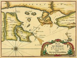
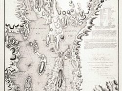
Bombay Harbour [Mumbai] 1778

$37.50
Drawn by shipmaster William Nichelson, this sea chart accurately details the location of sand bars, shoals and rocks, and notes tide marks, high and low water, and anchoring grounds. Printed by London mapsellers Sayer and Bennett as a navigational aid of this Indian port, the delicate coloring and wealth of information makes it both fascinating and decorative.
Size: 19 x 32 inches. Color, Cover-stock Paper